Chesapeake Bay Climate Adaptation Toolbox
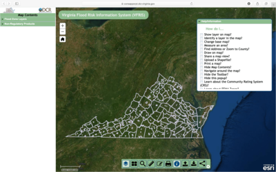
Virginia Flood Risk Information System (VFRIS)
Developed By: Virginia Institue of Marine Science (VIMS) Center for Coastal Resources Management (CCRM), and Virginia Department of Conservation and Recreation (VDCR)
Summary: The Virginia Flood Risk Information System uses an interactive map to display FEMA flood risk zones in Virginia.
This easy-to-use, interactive mapping tool allows users to quickly locate a property to determine if it is within a Special Flood Hazards Area (SFHA) or non-regulatory flood zone. In addition to the mapping tool, users can also search for and download FEMA reports and data including FIRM Panels, Flood Insurance Studies (FIS) and Flood Risk Reports (FRR). This tool includes an excellent “Help/Information” window, which provides instructions, data information, and links to additional resources.
Get This Tool: https://consapps.dcr.virginia.gov/VFRIS/
Geographic Coverage
- Virginia
Tags
- Real-time/Current
- Climate projections
- Jursidiction based
- Grid based
- Location specific
- Computer application
- Interactive interface/map
- Downloadable data
Cost
- Free
Skill Level
- Low