Chesapeake Bay Climate Adaptation Toolbox
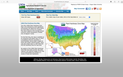
USDA Plant Hardiness Zone Map
Developed By: United States Department of Agriculture (USDA)
Summary: The United States Department of Agriculture (USDA) Plant hardiness Zone Map provides static and interactive maps to determine which plants are most likely to thrive at a location throughout the United States.
Useful for garden planning and local growers, this tool provides regionally specific data recommendations of plant hardiness zones. Using either the static or interactive map viewer, this tool allows user to determine plant hardiness zones throughout the US. Static maps are easily downloaded as jpegs or viewed on the web browser at national, regional, and local scales. The interactive map uses the same data. However, users can also zoom in on and ‘click’ on a point of interest. This brings up temperature averages and ranges for the specific location as well as its corresponding hardiness zone. There is also the option to adjust layer transparency in order to view hardiness with additional map layers such as roads and aerial imagery. This tool provides simple explanations of how hardiness zones are determined, and no previous knowledge or experience is necessary to use this tool. USDA hardiness zones are a commonly used planting guidelines. However, the provided hardiness zones are based on 30 years of minimum temperature extremes, and do not account for temperature changes due to climate change and uncertainty.
Get This Tool: https://planthardiness.ars.usda.gov
Geographic Coverage
- Contiguous United States
Tags
- Real-time/Current
- Grid based
- Computer application
- Interactive interface/map
Cost
- Free
Skill Level
- Low