Chesapeake Bay Climate Adaptation Toolbox
Mid-Atlantic Ocean Data Tool
Developed By: Mid-Atlantic Ocean Data Portal (MARCO)
Summary: The Mid-Atlantic Ocean Data Portal is a resource center consisting of an interactive map, data layers, case studies, and collaborative tools that allows users to explore and share visualizations of coastal and societal resources from New York to Virginia.
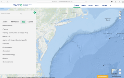
The primary component of this tool is an interactive “Marine Planner” map which allows users to display over 4,000 data layers representing ocean resources and human use data. Users can select which layers to display from nine drop down menus: administrative, fishing, marine life, oceanography, recreation, renewable energy, security, and socioeconomic, or use the search bar to find a specific layer. The tool also includes a “Data Catalog” in which users can find background information, download options, and links for the available data layers. This tool provides thorough documentation describing tool functions and applications through a variety of case studies and “How Tuesday” webinars. The tool is free to access, but users must register for a free account to access certain functions, such as uploading data and creating/joining collaborative teams with other users. Although users have the option to upload data to overlay with the provided data layers, data uploaded to the tool is session-based and cannot be saved within the map. The data portal is frequently updated and users are encouraged to provide feedback or share issues, comments, and experiences through email or Twitter.
Get This Tool: http://portal.midatlanticocean.org/
Geographic Coverage
- Delaware; Maryland; New Jersey; New York; Virginia
Tags
- Real-time/Current
- Regional level
- Computer application
- Interactive interface/map
- Compare scenarios/locations
- Downloadable data
- Downloadable results
Cost
- Free
Skill Level
- Medium