Chesapeake Bay Climate Adaptation Toolbox
Virginia Coastal Geospatial and Educational Mapping System (GEMS)
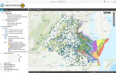
Developed By: Virginia Coastal Zone Management (VA CZM) Program
Summary: The Virginia Coastal Geospatial and Educational Mapping System (Coastal GEMS) is an interactive map and inventory of coastal resource data and conservation planning tools for Virginia’s coastal zone.
This easy-to-use tool integrates data from multiple natural resource agencies and other partners within a single mapping interface. Users can view and explore a variety of data layers ranging from coastal waters and wildlife, to population growth, shellfish management, and conservation planning. Within each layer, users can also find a comprehensive factsheet, providing relevant background information, links to the raw data or tool, and a description of the importance and management of the corresponding resource. Although this tool is focused on conservation planning, it also include layers relevant to climate change such as sea level rise projections, which can be overlaid to view the potential impacts of sea level rise on coastal resources. This interactive provides basic markup and searching functions, and map products can be easily exported to .pdf or .jpeg. Although there are no tutorials or case studies, this tool is easy to use and appropriate for users of all skill levels. Users should be aware that Coastal GEMS is ongoing, with additional layers being added and existing layers receiving varying degrees of maintenance.
Get This Tool: https://gaia.vcu.edu/GemsMap/
Geographic Coverage
- Coastal Virginia
Tags
- Real-time/Current
- Location specific
- State level
- Regional level
- Computer application
- Interactive interface/map
- Compare scenarios/locations
- Downloadable results
Cost
- Free
Skill Level
- Low