Chesapeake Bay Climate Adaptation Toolbox
Water Quality Assessment and TMDLs
Developed By: Maryland Department of the Environment (MDE)
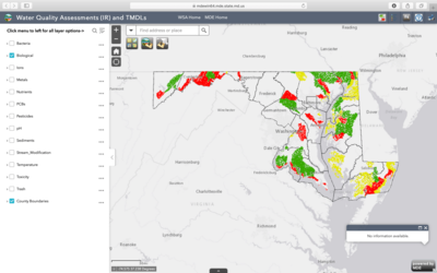
Summary: This interactive mapping tool displays surface water quality assessment information found in Maryland’s 2018 Integrated Report of Surface Water Quality (IR) as well as watersheds for which Total Maximum Daily Load (TMDL) analyses have been approved by EPA for Maryland.
Decisionmakers, environmental planners, and the public alike will find this map useful for determining what pollutants are in their water bodies, and where they are located. Through the interactive map, users can examine a variety of pollutant layers, such as nutrients, sediments, trash, metals, pesticides, and biological contaminants. Users may select a pollutant layer and water body to display the IR assessment information for that water body and pollutant. Users may also select a watershed to display TMDL information for a given pollutant. This map is designed to not only provide water quality assessment and TMDL information but also to show the spatial relationship of how each intersect. For instance, a water quality assessment might be made for a particular pollutant at a stream segment scale, but the TMDL addressing that stream segment would take into account all of the upstream sources of that pollutant within the stream segment’s watershed.
TMDL and water quality data are available to download as compressed file geodatabases. TMDL and the water quality assessment report are available for additional information.
Get This Tool: https://mdewin64.mde.state.md.us/WSA/IR-TMDL/index.html
Geographic Coverage
- Maryland
Tags
- Historical
- Real-time/Current
- State level
- Computer application
- Interactive interface/map
- Compare scenarios/locations
- Downloadable data
- Downloadable results
Cost
- Free
Skill Level
- Low