Chesapeake Bay Climate Adaptation Toolbox
FEMA’s National Flood Hazard Layer (NFHL) Viewer
Developed By: Federal Emergency Management Agency (FEMA)
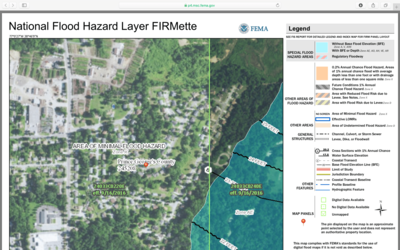
Summary: The National Flood Hazard Layer (NFHL) is an interactive mapping tool that allows users to view flood hazard maps and download Flood Insurance Rate Maps (FIRMS) from the Federal Emergency Management Agency (FEMA).
Through this tool, users can browse NFHL’s through a map interface, which includes official Flood Insurance Rate Maps (FIRMs) and revisions to FIRMS via Letters of Map Amendments and Letters of Map Revisions (LOMR’s). Users can find a FIRM for a location of interest by selecting a point from the map or searching for a site by address. After selecting a site, the NFHL automatically generates a FIRM or FIRMette (a smaller version of a FIRM) which can be exported and printed. All maps generated through the tool contain several basic map elements (ex: scale bars), but the format and content of available FIRM’s can vary. The National Flood Hazard Layer is considered the official database for the National Flood Insurance Program.
FIRM shapefiles and county information can be downloaded through the tool, however NFHL data, metadata, or FIRMette shapefiles must be requested from FEMA’s Flood Map Service Center. The tool is updated as studies go effective.
Get This Tool: https://hazards-fema.maps.arcgis.com/apps/webappviewer/index.html?id=8b0adb51996444d4879338b5529aa9cd
Geographic Coverage
- Contiguous United States
Tags
- Real-time/Current
- Jursidiction based
- Grid based
- Computer application
- Interactive interface/map
- Downloadable results
Cost
- Free
Skill Level
- Medium