Chesapeake Bay Climate Adaptation Toolbox
USGS National Water Dashboard
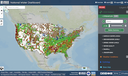
Developed By: United States Geological Survey (USGS)
Summary: The National Water Dashboard is a interactive map that shows reail-time water data colleged at USGS observation stations along with weather-related data from other public sources.
Get This Tool: https://dashboard.waterdata.usgs.gov/app/nwd/?region=lower48&aoi=default
Geographic Coverage
- Contiguous United States
Tags
- Real-time/Current
- Location specific
- Computer application
- Interactive interface/map
- Downloadable data
- Downloadable results
- Subdaily
Cost
- Free
Skill Level
- Low