Chesapeake Bay Climate Adaptation Toolbox
Surging Seas Risk Zone Map (SSRZM)
Developed By: Climate Central
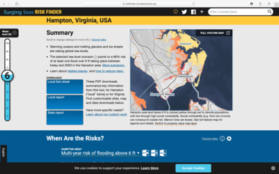
Summary: The Surging Seas Risk Zone Map (SSRZM) displays coastal areas predicted to experience the effects of sea level rise (SLR) within the U.S. The interactive map overlays allow the user to visualize the spatial extent of 1-10ft of SLR, while concurrently including risk factors such as population size, income, ethnicity, and infrastructural components. Users can refine the tool to exhibit specific scenarios, such as “Extreme Carbon Cuts” and “Unchecked pollution,” which alter SLR values depending upon particular coastal localities. The SSRZM offers the NOAA extreme scenario 2100, which is unlikely but increasingly plausible as a worst case scenario option.
Additionally, the SSRZM generates “City Stats” that provide the user with a localized report of map findings. City Stats also include figures for comparing scenarios expressed on the map that focus specifically on the flood risk timeline and social vulnerabilities.
Get This Tool: https://riskfinder.climatecentral.org/
Geographic Coverage
- Coastal Contiguous United States
Tags
- Real-time/Current
- Climate projections
- Jursidiction based
- Grid based
- Website
- Interactive interface/map
- Compare scenarios/locations
- Downloadable results
Cost
- Free
Skill Level
- Low