Chesapeake Bay Climate Adaptation Toolbox
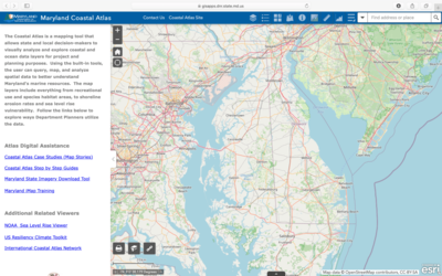
Maryland Coastal Atlas
Developed By: Maryland Department of Natural Resources (MDNR)
Summary: The Maryland Coastal Atlas is a mapping tool that allows users query, map, and analyze spatial data to better understand Maryland’s coastal and marine resources.
This mapping tool was designed to help state and local Decisionmakers analyze and explore coastal and ocean data layers for project and planning applications. The interactive map includes a variety of data layers, ranging from recreational uses of marine resources to shoreline rates of change. However, users also have the option to add additional data through ArcGIS online, URL links, or by uploading GIS data. This tool includes a coastal resiliency assessment layer, developed by the Maryland Department of Natural Resources and The Nature conservancy to identity priority restoration and conservation areas for enhancing coastal resiliency. Although no advanced training is required to use this tool, it also provides a variety of helpful case studies and tutorials.
Get This Tool: https://gisapps.dnr.state.md.us/coastalatlas/WAB2/
Geographic Coverage
- Maryland
Tags
- Real-time/Current
- Climate projections
- Jursidiction based
- Grid based
- Location specific
- State level
- Watershed level
- Computer application
- Interactive interface/map
- Compare scenarios/locations
- Downloadable results
Cost
- Free
Skill Level
- Low