Chesapeake Bay Climate Adaptation Toolbox
National Beach Nourishment Database
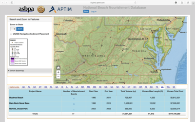
Developed By: American Shore & Beach Protection Agency, Regional Sediment Management Program, and APTIM
Summary: The National Beach Nourishment Viewer is an online database including project data from more than 3,000 beach nourishment projects across the US dating back to 1927.
This national level tool offers state specific information for over 3,000 beach nourishment project events such as cost, volume, funding source, and number of beach nourishment projects. Users can view projects nationwide or by state through a map viewer. The national map shows where nourishment projects have taken place, the number of nourishment events or episodes per project, and the relative cost of projects compared to others within the same state. The state scale provides a data table that includes volume of sediment and primary funding source. Users can also determine where nourishment sediment was dredged using the US Army Corps of Engineers (USACE) Sediment Placement feature.
The beach nourishment data included in this tool is provided by a multiple data sources, such as the Western Carolina University’s Beach Nourishment Viewer and the Florida Department of Environmental Protection. While the tool is relatively easy to use, users should be familiar with beach nourishment terms and techniques to interpret the provided data.
Get This Tool: https://gim2.aptim.com/ASBPANationwideRenourishment/
Geographic Coverage
- Coastal Contiguous United States
Tags
- Location specific
- Computer application
- Dataset
- Interactive interface/map
- Cost estimates
- Downloadable data
Cost
- Free
Skill Level
- Low