Chesapeake Bay Climate Adaptation Toolbox
Future Urban Climates
Developed By: University of Maryland Center for Environmental Science (UMCES)
Summary: The Future Urban Climates tool is an interactive map showing how climate may change within the next 60 years in 540 cities across the US.
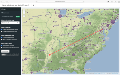
To describe what future climate may feel like across the US, this tool identifies present-days locations with a climate most similar to the climate that would expected by 2080 in each of the 540 cities. For example, in 60 years the climate of Washington, DC is expected to feel most like present-day Greenwood, Mississippi. Future climates projections are based on 27 climate models, with the option to view the projections as an average all models and/or each individual model projection. Users may choose to view future urban climates as the city with the most similar future climate or as a similarity range, which shows a larger region of climate similarity that addresses uncertainty within the climate models. The locations provided in this tool are the best fit for the cities. However, not all cities have a perfect future match to a present-day city climate. This uncertainty is illustrated by the size of the circle marking the city, with a larger circle showing higher uncertainty. This tool provides clear documentation describing how the to use the tool and underlying methodology. Further details are available in the provided paper.
Get This Tool: https://fitzlab.shinyapps.io/cityapp/
Geographic Coverage
- Contiguous United States
Tags
- Jursidiction based
- City level
- Computer application
- Interactive interface/map
- Compare scenarios/locations
Cost
- Free
Skill Level
- Low