Chesapeake Bay Climate Adaptation Toolbox
Coastal Change Analysis Program (C-CAP) Land Cover Atlas
Developed By: National Oceanic and Atmospheric Administration (NOAA) Office for Coastal Management
Summary: The Coastal Change Analysis Program (C-CAP) Land Cover Atlas is an interactive mapping tool that allows user to view changes in coastal land cover from 1996-2010 throughout the US.
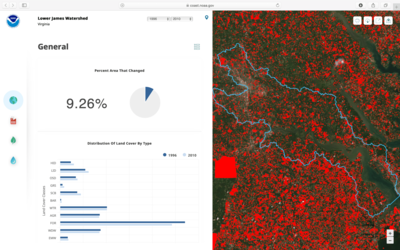
This easy-to-use tool provides access to coastal land cover and land cover change data developed by NOAA’s Coastal Change Analysis Program (C-CAP). Through the interactive mapping tool, users can view classified land cover data dating back to 1996. Users can also analyze local changes in land cover by watershed or county and choose from general, developed, forest, and wetland land use change.
Alongside maps of land use change, the C-CAP Land Cover Atlas also includes numerical summaries of trends, such as loss of forests new development, and increases in impervious surfaces. This tool strives to make land cover data accessible to users who do not have advanced skills or experience with GIS. The tool allows for easy data downloading and exporting across counties and watersheds.
Get This Tool: https://coast.noaa.gov/ccapatlas/
Geographic Coverage
- Coastal Contiguous United States
Tags
- Historical
- Real-time/Current
- Jursidiction based
- County level
- State level
- Watershed level
- Computer application
- Interactive interface/map
- Downloadable data
- Downloadable results
Cost
- Free
Skill Level
- Low