Chesapeake Bay Climate Adaptation Toolbox
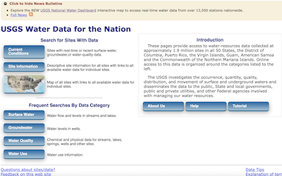
USGS Water Data for the Nation
Developed By: United States Geological Survey (USGS)
Summary: The USGS Water Data for the Nation allows users to view real time data from approximately 1.9 million stations that collect water data across the United States.
This tool allows users to search for water data by sites or by data category. To find the relevant sites, users can browse sites with current conditions data, descriptive site information, or a map of all sites with available water data. In addition, under current conditions the user can select to view data from predefined displays, which allow the user to either view tables of data or a map of station locations for streamflow, precipitation, groundwater, stage, and water quality data, view a Daily Streamflow Conditions map, or the tool directs them to external links that also have water data. The interactive map provides a geographic view of the location of sites with USGS water data. The user can also select the type of data they are interested in, such as daily data, water quality data, and more. Users can select an area to view by using the zoom function on the map or searching by place, site number, state, or watershed region. From the mapper, users can select sites and access data from those sites. Searching by data category allows the user to select from categories such as Surface Water, Groundwater, Water Quality, and Water Use, which supplies supplemental information about the data category as well as data for current and historical conditions. The real-time data are collected and stored onsite and transmitted to the USGS every 1 – 4 hours.
Get This Tool: https://waterdata.usgs.gov/nwis/
Geographic Coverage
- Contiguous United States
Tags
- Historical
- Real-time/Current
- Location specific
- Website
- Dataset
- Interactive interface/map
- Downloadable data
- Downloadable results
Cost
- Free
Skill Level
- Low