Chesapeake Bay Climate Adaptation Toolbox
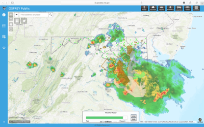
OSPREY Public
Developed By: National Oceanic and Atmospheric Administration (NOAA) National Weather Service (NWS)
Summary: Operation and Situational Preparedness for Responding to an Emergency (OSPREY) is an interactive map for Maryland that presents users with statewide current conditions on weather, traffic, and electrical outages.
This detailed interface offers a broad range of information to aid emergency management planning, while remaining simple and easy-to-use. Data is updated in real time, and features components such as traffic incidents, flooding, radar, and power outages. Context layers such as FEMA Floodplains, and hospital and shelter locations direct the user to resources for planning emergency responses. Seasonal weather conditions and emergency alerts are also available., such as Active Hurricane layers and Snow/Ice Storm layers. Users have the option of searching an address or county to refine results.
OSPREY is supported by MD iMAP and is associated with the National Weather Service for DC/Baltimore Twitter account (@NWS_BaltWash), which users may follow to receive daily weather updates for the region.
Get This Tool: https://geodata.md.gov/ospreypublic/
Geographic Coverage
- Maryland
Tags
- Real-time/Current
- Location specific
- State level
- Computer application
- Interactive interface/map
Cost
- Free
Skill Level
- Low