Chesapeake Bay Climate Adaptation Toolbox
Targeted Subwatersheds
Developed By: DC Department of Energy and Environment (DOEE)
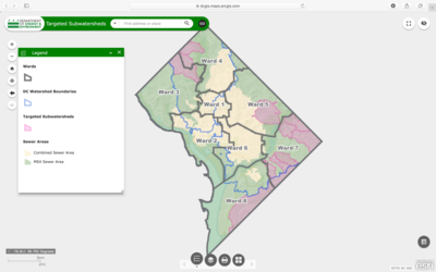
Summary: Targeted Subwatersheds is a simple mapping tool that displays watershed boundaries, TMDL subwatersheds targeted for Waste Load Allocation (WLA) prioritization, as well as the D.C. combined sewer area and MS4 area.
The purpose of this map is to show the overlap of the subwatersheds and combined sewer system. Users can print the map or export a table of the watershed/sewer boundary locations.
Get This Tool: https://dcgis.maps.arcgis.com/apps/webappviewer/index.html?id=d872faed1f8642d190c45befed97c760
Geographic Coverage
- Washington, DC
Tags
- Real-time/Current
- Jursidiction based
- City level
- Dataset
- Interactive interface/map
- Downloadable data
- Downloadable results
Cost
- Free
Skill Level
- Low