Chesapeake Bay Climate Adaptation Toolbox
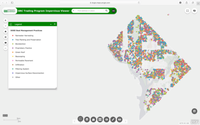
SRC Trading Program Impervious Viewer
Developed By: DC Department of Energy and Environment (DOEE)
Summary: The SRC Trading Impervious Viewer is an interactive mapping tool that displays large impervious surfaces such as parking lots, driveways, and buildings in the District of Columbia. This viewer allows users to locate areas that may qualify for Stormwater Retention Credits (SRC) projects.
This viewer displays large impervious surfaces that may be eligible for SRC projects as well as existing Best Management Practice projects from the Department of Energy and Environment (DOEE). However, users should be aware that impervious areas have not been vetted for their suitability for SRC projects.
To view areas of impervious surfaces, the user must first either navigate to, or search for an area of interest. Users may also view additional data layers such as wetlands, watersheds, and combined sewer areas, or upload their own GIS data. This easy-to-use mapping tool also offers various “Draw”, “Measure”, and “Print” tools with which users may annotate and export the finished product.
Get This Tool: https://dcgis.maps.arcgis.com/apps/webappviewer/index.html?id=92dca0c84d974a0c9ecc0858a110bf2d
Geographic Coverage
- Washington, DC
Tags
- Real-time/Current
- Jursidiction based
- City level
- Dataset
- Interactive interface/map
- Downloadable data
- Downloadable results
Cost
- Free
Skill Level
- Low