Chesapeake Bay Climate Adaptation Toolbox
DC Flood Risk Map
Developed By: DC Department of Energy and Environment (DOEE)
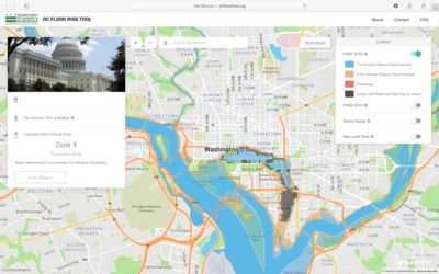
Summary: The DC Flood Risk Tool uses an interactive map to display the risk of various types of flooding throughout the District.
This easy-to-use tool was designed to identify the potential flood impacts of a particular site. The map includes layers showing the 2010 and 2016 FEMA Flood Insurance Rate Maps (FIRMs), as well as storm surge and future sea level rise. Users can easily search or navigate to a property of interest and select the property to learn the assigned flood zone and tax assessed value. For properties in the 100-year flood zone, users can also estimate the potential cost of structural losses resulting from a 100-year flood. Users may also download a 1-page report including a map and description of the property’s flood risk. However, mapping options are limited.
Get This Tool: http://dcfloodrisk.org/
Geographic Coverage
- Washington, DC
Tags
- Real-time/Current
- Forecast
- Jursidiction based
- City level
- Computer application
- Interactive interface/map
- Compare scenarios/locations
- Downloadable results
Cost
- Free
Skill Level
- Low