Chesapeake Bay Climate Adaptation Toolbox
Green Infrastructure Practices in the District
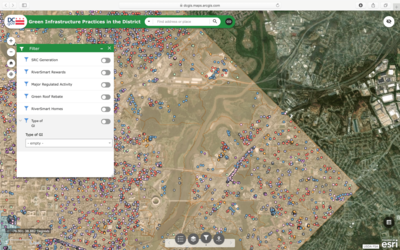
Developed By: DC Department of Energy and Environment (DOEE)
Summary: This interactive mapping tool displays locations within Washington D.C. that have installed Green Infrastructure (GI) practices.
The Green Infrastructure Practices map displays common Best Management Practices (BMP) that manage stormwater runoff throughout the District, such as green roofs and rainwater harvesting systems. The map distinguishes the extent of the three watersheds within the District, displays practices eligible for Stormwater Retention Credits (SRC), and recognizes buildings that have a Green Roof Rebate. These features enable Decisionmakers and homeowners alike to plan for environmentally conscious development and recognize where GI has been implemented. Users can view the data from “Layers” in GIS, and all data is available for download from http://opendata.dc.gov/datasets/best-management-practices.
Get This Tool: https://dcgis.maps.arcgis.com/apps/webappviewer/index.html?id=cc7f1d49c5074427a28f76154543fa98
Geographic Coverage
- Washington, DC
Tags
- Real-time/Current
- Jursidiction based
- City level
- Computer application
- Dataset
- Interactive interface/map
- Compare scenarios/locations
- Downloadable data
- Downloadable results
Cost
- Free
Skill Level
- Low